Monday, June 15, 2020

Pachaug Doorstep Adventure

A small stream flows beneath High Ledge in Patchaug State Forest

Friday
I signed out from the videoconference, flipped my laptop shut, reached for my rucksack, then stepped out into a bluebird Friday afternoon. Memorial Day weekend had begun. I intended to capitalize on every minute. 
The Covid-19 pandemic has changed many things in our lives, including the way people travel. Fortunately, my preferred travel medium, the doorstep adventure, did not require any fear-filled plane rides or dubious highway rest stations. 
 My doorstep in southeastern Connecticut would be the start and finish line for a 60+ mile trail loop through Pachaug State Forest —the largest state forest in Connecticut. There were parts of this forest in the south that I knew very well, but there were also other places in its northern reaches where I had never set foot. I found myself deeply curious about what the trails would be like up there.

Since this was a doorstep adventure, I had to get to the trailhead under my own power. I started shambling through the neighborhood, loaded pack pressing on my shoulders. While the weight made it too heavy for me to truly run, I found I could move slightly faster than walking speed if I broke into a granny-gait on the flats and downhills. 
I ducked into the woods for a quick shortcut, then popped out again at at the base of Lantern Hill, where (no surprise) the road was lined with hikers’ vehicles. There were exactly zero people on the abandoned trolley line nearby however, which worked out nicely.
It used to be possible to follow the trolley line all the way to the Narragansett Trail, but when I tried to explore that route last year, I’d found someone had set up No Trespassing signs and an electric fence — which I’d avoided by pushing through a wall of briars and climbing up a stone dam.
To avoid doing this again, I cut into the woods early, sloshed across a mucky stream, and came out near a graveyard on Route 2. I shuffled along the roadside for a half-mile or so before reconnecting with the Narragansett Trail in a half mile.
The trail was marked with the blue blazes that indicated that it was maintained by the Connecticut Forest and Park Association— the organization which maintains over 700 miles of these blue-blazed trails throughout the state.

The Narragansett Trail would be my companion for the beginning of this adventure, before I turned north onto the Pachaug Trail. The companionship started rocky, with a butt-kicking climb up a steep ridge. The trail dropped down again into the Yawbux Valley, along a heartbreakingly beautiful stretch of beaver-dammed brook. 
The trail wended past a second beaver pond, then took to the hills again, through old stone walls, beneath tall, dark outcrops of layered schist. Often, I think the tortured rock formations in the Connecticut woods go unappreciated simply because they are so deep in the trees. You don’t see them until you are right in front. Moss and mountain laurel often favor such places. They have their own brooding flavor. I passed over the geologic chaos of High Ledge and Bullet Ledge, where the rocks are cracked and jumbled violently atop one another. 
For camp, I climbed another ledge off the trail, and draped my tarp over a fallen branch.
The mashed potato dinner was bland, but enjoyable. I’d shattered some potato chips into the mix earlier, which added a nice oily quality to the meal. I zipped myself into the bivuac sack, shut my eyes and waited for sleep. 

(Top to bottom) I start on the roads, Yawbux Valley, Beaver Dam, High Ledge, dinner

Saturday
It poured that night. At one point, I had a troubled dream that I was sitting in on another video conference, but in every square, instead of a human face there was a whining mosquito. When I awakened I realized that I was, in fact, surrounded by a mosquito swarm. They probed at the defenses of the netting, looking for a weakness. 
I listened to the whining chorus until I could take it no longer. I shot out from the bag and started packing like mad. By 5 a.m. I was already picking my way back down off the ledge and going for the trail. Breakfast could wait.
The night’s rains had suffused the woods with brooding fog. The trail went down and down into a ravine, where I filled my hydration bladder in the swift-flowing brook that ran along its bottom.
Further up, the trail joined the gravel Legenwood Road and headed east. A sign announced that due to a property dispute, that I couldn’t just follow the blue blazes back into the woods, but had to take a detour on the roads for the next couple miles.
I minded this far less than I thought I would. Traffic was light enough that it hardly bothered me. Stone-walled farm fields were ethereal in the gray mist. I was making incredibly good time with my early start and the roads allowed me to take on even more miles. When I had the chance to rejoin the Narraganset again earlier, I opted instead to push on along the pavement to the next crossover — saving myself 30 minutes or more.
I re-met the trail at the Green Fall River, which cuts a narrow canyon through the rock. It was an area of perpetual shade, with cedars and hemlocks growing thick along the ledges, while ferns and moss flourished in the understory. The river’s cola-brown waters foamed and gurgled below in a series of small falls. The path crossed the river, followed a boardwalk, then climbed past a dam to the quiet shoreline of Green Fall Pond.
I remembered these places from elementary school when my summer day camp would take everyone out there in vans, our teeth rattling as we drove along the bumpy forest roads. It had been many years since I’d hiked there last, and I wondered if, all these years later, I might no longer find the place so alluring and beautiful. I needn’t have worried.

 Though I had been travelling in known territory, that was about to change. At the north end of the lake, I found another blue-blazed route. I consulted the pages from the Connecticut Walk Book that I’d brought with me to confirm that this was, indeed, the Pachaug Trail.
I followed it north, winding through another series of dark, rocky ridges and shattered boulders.
Further along, the trail flattened out onto a plain of glacial silt. Pitch pines, with their distinct, lizard scale bark and urchin-like needles grew comfortably here.

An hour later, I emerged at a highway where the blue blazes led me toward Beach Pond. The pond is actually a three-mile long lake, straddling Rhode Island and Connecticut. Today, it was gray and still. A solitary fisherman cast his line from a canoe. 
Rhode Island still officially required out-of-state visitors to undergo a two-week quarantine. Judging by the stream of Rhode Island plates flowing past along the highway, it didn’t seem that the state’s residents were taking things too seriously. I crossed the line, then turned north off the highway as the trail re-entered the trees. 
The trail went up and down along the lakeshore through groves of pitch pine and beech trees. I cooked hot breakfast along a boulder at the water’s edge. A light rain prompted me to wrap myself in a tarp — probably a strange sight for the water skier that went buzzing past.
The rain diminished by the time that I packed up. I crossed back into Connecticut, then proceeded north beyond the lake. My goal for the day was about 10 miles or so to the north. This would be the northernmost extent of the Pachaug Trail before it bent west. It was also at a 560-foot hill called Pharisee Rock, that I intended to climb.
The woods were darkening now; the air became oppressive, heavy. Sure enough, I started to hear the splat of droplets on the leaf canopy. A nearby collection of fallen rocks made a decent-sized cave. According to theI crawled in to eat a Clif bar as the rain began to splatter, then thunder in a steady downpour as the wind shook the branches. I waited 15 minutes to see if it would pass. When I saw that it wouldn’t, I wrapped my pack up in the tarp and threw my poncho on.

The next hours were a soaking slop show. I sloshed through ankle-deep puddles as the rain fell and fell, clutching myself beneath the poncho as I jogged. I was mightily tempted to put on warmer clothes, but also reluctant to dampen anything that I would sleep in that night.
When I saw the sign for the Pharisee Rock trail, I laughed out loud. The rain was slacking, and I decided that it was as good a time as any to pitch camp.  
I pulled on all my warm clothing, and my insulated hat, then lay in the sleeping bag for the next hour, clutching at myself to get warm. I partially extricated myself to cook dinner again, but then got back in the cocoon. Despite my efforts, damp had found its way in. I clenched myself harder. I wasn’t hypothermic, but I was far from comfortable. At least it was too cold for the bugs.


Narrow section on the Pachaug Trail, The Rhode Island line, shelter

Sunday
I was awake around 6 am, feeling miserably cold and pessimistic about whether getting out of the sleeping bag would make things any better. Eventually, the need to answer the call of nature forced the issue. Once on my feet, I discovered that those feet were sore — so were my legs. Everything was battered and creaky. I started up the trail, packless, toward the summit of Pharisee Rock. 
My efforts were rewarded with a lackluster summit view. The only thing that I could see through the trees were the tops of other trees, slightly that were further off. No matter. Sometimes things just work out that way. I stumbled my way back to camp and packed things up. I was back on the trail a little before 8 am. 

 Even if Pharisee wasn’t much to write home about, I got an unexpected lift from the road-walk section of the trail as it followed a high ridge above farm-fields with a panoramic view toward hazy hilltops. The sun was starting to slash away the clouds now and droplets on the hay scintillated like incandescent pearls. Dozens of tiny birds flitted in and out along the fence line in a tittering cacophony. A watchful hawk soared high above it all, looking for its next meal. A bouquet of flavors rose wafted out of the warming grass and into my nostrils. I felt serene and joyous. 
Just as a sponge takes in more water, the longer it soaks, so do travelers take in more the longer they spend in the works of nature. I believe the length of time spent is often more relevant than the location. Even hiking along pavement, now that I was on the third day of my trip, I felt a serenity on par with anything that I’ve felt in a National Park trail.
A sign outside a recent high school graduate’s house let me know I was in the town of Sterling now. I’d really gone north, almost halfway to Massachusetts now. Often, living in Connecticut, I overlook these parts of the state because I get so taken by the coastline. Now I thought that I ought to have been looking over my shoulder more. The Connecticut Interior had its own peaceful beauty that I was appreciating more and more with each step. 

I followed the trail back into the woods where a crow-sized pileated woodpecker soared over my head, then regarded me from the side of a tree trunk. I could perceive a distant lakeshore through the trees and heard its chorus of peepers and bullfrogs. New smells of hot pine needles wafted up from the ground. All these sensations enlivened me as much as the roadside had. I broke back into my granny gait.
I was making good enough time that I decided to add some miles by hiking over to the adjacent Quinebaug Trail. I took a connector through the woods over to Phillips Pond where a sunny picnic table by the lake’s edge made for an attractive picnic spot.
Once again, I was glad I’d waited to eat along the trail instead of shivering through the motions in camp. I kicked my shoes off and set up damp clothing in the warm sun. I enjoyed a languid breakfast, finishing the last of my oatmeal in a double ration while my clothes dried out. 

I continued south along the blue blazes on the Quinebaug Trail, joining a rutted-up forest road. A set of dirt-bikers zoomed past from the other direction. 
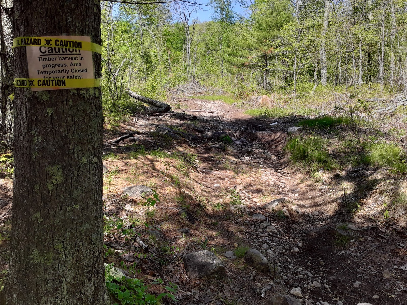
Then I saw the sign: “Timber Harvest in Progress: Area Temporarily Closed for Your Safety.” It was Sunday, so I seriously doubted any of the big equipment would be rolling. Still, I hesitated. I had a history of getting lost in logging areas with their morasses of confusing skidder paths. Turning around would mean backtracking two miles to the Pachaug Trail, however. Maybe, I could finesse my way through this time. 
Following the main track seemed to be easy enough. Sometimes there were even blue blazes on trees that hadn’t been toppled. By the time the bulldozed path came out at a forest service road. It seemed that I had navigated my way through successfully. After 45 minutes of kicking along the gravel with no sign of a blue blaze anywhere, I concluded that I had screwed up. The forest roads were not so much fun in the high sun. The trees were cut back far enough from the margin that I enjoyed approximately zero percent of their shade. There were other trails leading into the woods, but I still didn’t see any blazes. What had happened?
I finally made the ultimate capitulation and (ugh!) took my phone out to find my location.  I eventually figured out that I had come out of the woods to a different road than I had expected. The good news was I could regain the trail in about a half mile of road walking. 

Finally, I got back to the blue blazes. I had switched over to the Nehantic Trail, which would loop me back to Green Fall Pond. I followed the path up a slope to the top of Mount Misery, a popular overlook where I had to take turns with other Memorial Day hikers to appreciate the view. 
The parking lot at the base was crowded with vehicles and hikers. There was a large, closed-up campground where the state had stacked picnic tables atop one another so people wouldn’t use them. At another site, I saw a large group gathered having a cookout. It didn’t look very socially distant. Sure enough, a ranger pulled up soon afterward to talk with them. 
Shortly thereafter, I missed another key turn and walked for a miserable stretch of busy highway before I realized I needed to turn around. Finally, I got back into a long stretch of woods for me to walk and jog.
I popped back out at Green Fall Pond at around 5 pm. I had completed the lasso. Now I just needed to retrace the Narragansett Trail to get home. Much like Mount Misery, the area was busy. Crowds of people paddled along the lake and gathered on the ledges above the water. Almost all of the vehicles in the lot had Rhode Island plates. 

At this point my legs were pretty shot. I hiked back through the Green Fall canyon and onto the section of trail I had skipped the other day. I found a flat section to set up camp near the river’s edge. Of course, being this close to water meant that the bugs came out in droves. 
I cooked dinner quickly, then zipped myself into the bivy while Mosquitopocalypse swarmed in.
They climbed the mesh of the bivy sack like pirates crawling up the rigging of a Spanish galleon but thrust their blood-hungry proboscises through the nylon in vain.


Morning in Sterling, CT; Why yes, I've been wearing fingerless gloves, how could you tell?; logging; view from Mount Misery, not a picnic spot 


Memorial Day
The last morning on the trail was gray again and misty. I had to walk carefully over slippery rocks and through muddy stream crossings. I ran the roads back to Legenwood, and then skipped the whole Bullet Ledge section of trail. At the base of High Ledge, I stopped to pick a bunch of stinging nettles to cook for dinner that night — I hadn’t enjoyed eating nettles since Washington. Just to make sure they were the real deal, I ran the back of my hand over the leaves until I felt the painful sting. They would be far more enjoyable after simmering in a frying pan.
The Yawbux Valley was particularly beautiful in the gray. I stopped to watch the antics of a family of geese leading their goslings through the trees around pond. I loitered around the sprays of wild azalea blossoms sticking my nose in them in search of fragrance. I hadn’t seen a soul along the trail all morning. 
In the next couple hours, I would retrace my way along Route 2, the trolley line and the remaining roads leading home. I would log about 68 miles of trail over one Memorial Day weekend. 
I stopped to fill my water one last time, nestled in the cool beneath the hemlocks along Yawbux brook.
I paused and listened to the conversations of the birds, watched the dark water swirl around mossy rocks.  Bubbles and flecks of foam spun in tiny eddies. Water bugs skittered across the surface on their separate missions. 
To be sure, the small place was easy to scoot past on the way to more dramatic sights, but it also had its own patterns and stories to tell. Taking time to appreciate such things fit nicely with the theme of my morning — with the whole doorstep adventure.


Trailside stinging nettle and wild azaleas

Friday, April 5, 2019

A bikeyaking adventure through Mystic

The bikeyak at the launch site in Old Mystic

A note on doorstep adventures:
  You are about to read another entry in my Doorstep Adventure portfolio.
  The concept is simple: Start the adventure at your door; finish the adventure at your door. 
   By the way, you're not allowed to use cars, planes or any other vehicles that burn fuel. In a world threatened by climate change, I'm not content to be another “nature-lover” jetting around the planet, trailing carbon emissions in my wake.
  Doorstep adventuring is a lot harder than regular adventuring, and it ain't always fun. A doorstep adventurer may start an alpine trip with a 20-mile bike ride, skis or snowshoes strapped to the frame. Kayak voyages require even more inventiveness
In any of these cases, If you are willing to accept the demands, the reward of arriving at last is multitudes more satisfying.
   In an era when you can access virtually any place on earth in relatively short order, it’s no longer the challenge of getting there that matters. What matters is how you get there.

Pedaling
The driver in the pickup swooped in on a blind curve and mashed down on the accelerator. I glued my eyes to the edge of the pavement, gripped the bike handlebars tight. I felt a little vulnerable with a 16-foot kayak trailering behind.
I planned to pedal the four miles from home down to the nearest coastal access, paddle for a couple hours and then get back on the bike to bring it all back. 
It was the first time I had tried biking with a sea kayak (I have biked with a shorter whitewater boat.) If I made it to the launch, I would have the satisfaction of moving my boat over land while leaving my polluting car in the driveway.

But I had to get through Lantern Hill Road first.
Designed without even the fleeting comfort of a painted margin, Lantern Hill Road once served the needs of a what was a sleepy rural community in southeastern Connecticut. Now, it is a corridor between Mystic tourism, Interstate 95 and one of the world’s largest casinos. There are also a lot of asshole drivers. I can’t say that the profusion of Fireball nip bottles littering the roadside has instilled much confidence either.
The thing was, I couldn’t move all the way over. The aluminum kayak carriage provided decent tracking, inflatable tires that could take a bump, and good balance — but it also gave me a wider profile that forced me to ride closer to traffic.
If I veered too far to the right, I risked hitting rocks or brush, and flopping out on asphalt.
Another thing to consider: visibility. I have a six-foot profile riding on my bike, but my kayak was a third of that. A driver coming up a rise could miss it easily.
Measures that I’d taken to prevent my boat from becoming another roadside statistic included clipping a bright yellow dry bag to the back, and stringing yellow line over the small “mast” that I’d rigged up using half of my spare paddle. An orange fishing glove at the top stood out like a Day-Glo rooster’s comb.
This was apparently visible enough, to the truck coming up behind me, which swerved wide. I slowed down to a mile an hour to let it blow past. The driver had maybe half a second to react if there were a vehicle coming around the curve from the other direction. 
Exhale.
With the engine noise past me, I could hear spring peepers chirruping from a nearby wetland. I rode at the speed of a 5K jogger, alongside stone walls and soggy corn fields, scarcely minding the burden behind me rear wheel. That was until I heard the next engine bearing down.
Much of road riding went this way: pastoral contemplation interspersed by sphincter-clenching moments.
I’d learned to keep my momentum for the uphills, or else the rig tended to wobble, then fishtail violently and force a dismount. The busy Gold Star Highway intersection was on an uphill as it happened, but I was blessed with a rare gap in traffic. I blew through the red flashing light, climbed up to North Stonington Road and cruised the rest of the way to Old Mystic. After one more tricky intersection I rolled up to the put-in off Route 27.

The start of the Mystic River at high tide
Paddling
The Mystic River starts where the dark water of Whitford Brook burbles through stone walls to a tidal marsh. I pulled the bikeyak into a small parking lot adjoining a brick building that used to be a flag mill.
The tide was out. By that time that I had locked up the bike and unstrapped the kayak, which I had to lower almost four feet down fieldstone wall to reach the lazy-flowing water. 
This was not the typical place where I would launch a kayak in this area, as I would usually drive out to more open water in Long Island Sound. Today, I appreciated drifting languidly between the sedges. Geese and ducks meandered along the surface. Up higher, on a wooden platform, an osprey tended to its nest. Despite the tidal influence, the spring runoff from Whitford made the water taste completely fresh. Even as the river bloated out to a quarter mile wide, I could barely taste the salt intruding from the ocean.
The water had turned deeper and saltier by the time I passed beneath the I-95 bridge. A stiff south wind rose up to challenge me. I slunk away from the confrontation, slipping into unruffled water behind points of land.
I glided past wooden ships at Mystic Seaport with apprentices in the rigging, past winterized yachts still under tarps and beneath the drawbridge that connects Downtown Mystic. I had plenty of winter rust to shake from my paddle rhythm. My focus was less on the scenery, more on getting my body synched up properly as I scooted past all the familiar landmarks.
Mason’s Island at the river mouth gave me the choice of heading east or west. I chose east and was soon glad for it. First, I saw another osprey landing near its nest. I think it was feeding chicks.
Passing Dodges Island, I got a real treat when I flashed on a large, shiny object sitting on a rock.
Hey, isn’t that a —
Too late. The seal splashed into the water.
About a minute later, however, I saw about a dozen of the harbor seals, gurgling and growling at each other on a cluster of nearby boulders. I kept my distance this time, so they wouldn’t take to the water. They were just a group of sausage forms in my field of vision, but the satisfaction of the find was immense. I had seen seals many times before out on Fishers Island, just south of the border of the New York State border, but it was the first time I’d seen more than one seal in Connecticut waters.
Now that I was out on open water, the hazy shore of Fishers was in reach if I wanted to push myself. Even farther, to the east, lay Napatree Point in Rhode Island, where I might have wrangled a surf spot out of the open ocean exposure.
Yet, my bike was still in Old Mystic and I was already burning the afternoon. Maybe I shouldn’t get too cocky. I skipped the long crossing to Fishers and paddled east instead, following the Stonington shoreline for a couple miles until I managed to wrangle a weird little surf spot in front of somebody’s multi-million dollar mansion. 

The waves in Fishers Island Sound rose only six-inches or so, but there was a thin stone ledge that refracted them into each other and boosted their height—similar to how a magnifying glass turns up the heat of the sun. In that narrow zone, the waves built to a couple feet high, then curled over into a small but fun break.
I angled in from the left, caught a quick diagonal down the face of a wave and squirted out the other side before it could crash me into the rocks on shore. 
The second time I set up, there was a larger wave approaching the magnifying glass. I accelerated as the wave grew, pushed me sideways and then crashed over the boat up to my armpits. I braced my paddle into the whitewater, then spun out of the carnage. A gallon or so of water had slopped onto my shirt from beneath my raincoat. Hadn’t seen that one coming. 
I briefly regretted leaving my drysuit at home, but the air was warm enough that the chill passed quickly. It was about time to head back.
I poked into a couple of coves, then rode the flooding tide and tailwind back to Old Mystic. The high tide gave me license to paddle up Whitford Brook a short ways before I started hitting rocks. It also allowed me to get out of my boat much more easily than I had gotten in, as the water was now much closer to the top of the stone wall.
It took another half hour to move from kayak cockpit to bicycle seat, re-rigging the trailer and changing my clothes. The lowering sun inspired me to also turn my headlamp backwards and set it on blinker.
The ride home was a smooth one and by the time I’d finished, I still had enough energy left in the can. I suppose I could have paddled out to Fishers after all, but no matter. I’d proved that I could do it.
Moving a sea kayak overland has always felt like the moon-shot of my doorstep adventuring. I’ve usually conceded, reluctantly, that it really is so much easier to throw the boat on the roof and let the car do the work, you know, the way everyone else does it.
Yet here I had taken on that challenge and still managed to get a quality outing with surf and seals. I had grossed about 16-miles of kayaking all together. Biking the kayak was more work than it would have been to drive, but it wasn’t so onerous that it defined the experience. The paddling did that.

Foam from Whitford Brook gathers at the start of the Mystic River

Monday, April 1, 2019

The backyard ski run and other micro-adventures in the Connecticut winter

Video: A backyard ski run in Connecticut

Skis
   
Let’s be clear: to many people, there is something a little sad about a full-grown adult trying to recreate childhood memories by hauling trash barrels full of snow from the porch into the woods to get the right coverage on a tiny backyard ski run.
    There is also something sad when winter in Connecticut is all gray skies and wet leaves, when a sickly veneer of snow on the ground is the only chance to relive the sweet effortlessness of gliding between the maples and birches. 
    I worked diligently with the shovel, scooping the inch-thick layer of snow off the duff around the trail, hurling scoopfuls of it onto bare moss. Here and there, I stopped to remove clumps of dirt and leaves from the smooth surface I wanted to build.
   Yes, I could have just driven north to miles of skiing in New Hampshire that would have been worlds better than anything I’d hope to build in Ledyard. That wasn’t the point.
    It was the principle of the thing, dammit. Our town had been cheated out of the snow it deserved. Going north to borrow somebody else’s snow did not rectify the injustice, nor did it supply the satisfaction of skiing on the home turf.
    If Connecticut was only getting an inch, well, then I’d rise to the challenge.
    Yet, the snow gods deserved more credit than I’d given them the first time.
    A second helping of snowfall the next day gave me just enough  coverage to cruise further out onto some of the trails in the backwoods, hitting twigs, scraping over rocks, revisiting an old hill further down the path that put a rock through my knee a decade ago.
    I even managed to visit some maple taps to collect sap from the buckets.
    After I got my fill of this, I got back to work. I knew that if I was going to ski for more than a couple days the course would require more human intervention. I added what I could from the leaves and skied back and forth over it to pack it all down, into a fast and narrow run, with a tiny jump made from a rock I’d buried in the middle of the trail.
    When I had the temerity to go down the slope in my skinny track skis, I caught a glorious slice of air at the bump, then fell on my ass trying to make the curve. This was when several people were watching, of course.
    Snow melting and re-freezing eventually turned the slope into an icy death chute. The stone walls on either side left no room to kill momentum with a snowplow. It was just point ‘em and pray, hope for the best at the end. Afternoon sun eventually broke the ice into corn mush, that was still fast but mercifully had enough give so I could sink ski edges in and take control.
    I got to spend a couple weeks with my miniature course as the cold lingered over weeks, running it many times. I even cleared a secondary route through brush to make the course into  a lollypop-shaped loop. I went back to weak spots and piled more snow where necessary. I began to become aware of intricacies of the run, like a minute gap in the wall where I could throw out a quick snowplow if I needed to kill speed.
    I loved the course all the more for all the work I put in. 
    Watching snow melt is like saying goodbye to an old friend. I hope it wasn’t for the last time.

Axes
    The bitterest weeks of cold froze Long Pond thick enough to walk over, even froze the waterfall above Bush Pond.
    One afternoon, I decided to shuffle over to the frozen wall with ice axes and crampons with the intent of scaling the beast for the first time.
    It was about a 12-foot falls, with water still flowing beneath the ice. If the ice broke away, it would dump me onto the broken rock below, but I weighed the risk against the fact that I might never again have a chance to climb those falls.
    First, I went up the easiest route, which followed the main watercourse. I’d gone this way barefoot in the summertime, with axes and crampons it was no problem. But that wasn’t really the kind of climbing I had come out for.
    I went around back to the base and took a vertical route on thinner ice. This time the axe bounced back once or twice, and I had to spend uncomfortable minutes standing on my crampon points whacking the axe into different spots until I found a hold that I could pull myself on. I topped out by jabbing the an axe shaft through the thin ice above the pool of water at the top. It wasn’t much, but it was enough to hold a bit of weight while I got a knee up, then bent myself over the edge to safety.
    The third ascent, I chose the route with the thinnest ice. Here, it was shellacked to granite in hard, white nodules the far right of the falls. Once again, I found myself hitting the ice again and again in different places, until finally, I could pull the axe down with enough confidence to trust my weight on it. I teetered at the top, feeling the bite of my crampons weakening as I slammed the axe point into one place and then another, only to have it bounce right out. 
    Crap. What was I going to do now? Finally, I got a tiny bite on the axe, that gave me cover enough to make the final movement and stand at the top of the ice.
    Three ascents were good enough for me. My fingers were going numb. I walked back home over the frozen lake as wind clashed the branches of the trees together and the sun setting over Cider Hill lit the troubled sky into clots of gray and orange. 

Skates
    I finally found some ice skates I could borrow, just in time for the lake ice to remelt a little and then re-freeze into a perfect black sheen. I love how ice changes the meaning of Long Pond and it is suddenly possible to waltz right over to North Stonington, or cruise past the coves at speeds that would be unthinkable in a kayak. My dad and I got out a few times to enjoy the new perspective.
     A friend and I even tried holding a tarp between us as the wind blew for a fast ride going north. Mostly, I skated under my own power — skated sloppily at that — but enjoyed the quest to find the rhythm, and think about nothing else but how to move with grace, maximum economy.
    There was one small, hacking problem: a nasty cold, or maybe I can call it an upper respiratory infection given that it stuck with me for a month. I stopped here and there throughout these excursions to double over into coughing fits, marveling at the pain that I felt at the back of my ribs. But who could know when Long Pond will freeze up like this again? I had to be out there.
    At night, the expanding and contracting ice would make those haunting chunking noises, skittering and cracking, filling the night air with reverberations from the lake bottom.
    It is a sound that most of us in Connecticut don’t get to hear often, certainly not as often as we should. The voice of the ice strokes a wild part in the listener’s soul, reminds us that there was a time when wolves ran in the hillsides here, leaving footprints in the snow. 

    Those lucky enough will hear the echoes of the ice come up through the windows of their homes. They will cherish the wild that is left for us here — then turn back to their screens, turn up the volume and turn up the heat.

Tuesday, January 22, 2019

Rare Ice


As the blood moon hung in an ice sky above Long Pond, the forces of the rare and the strange were weaving together a different, yet just as singular phenomenon — one that I would discover by the light of the next day. 
What was rare (other than the strange moon) about that evening?
The temperature was one thing.
When the rain had been falling the previous morning, it had been close to 50 degrees in Ledyard, Connecticut. Yet, all that water spilled out on the layer of black ice over Long Pond, a remnant of the freezing conditions earlier. As the rain let up, the wind began to howl.
Gale winds ripped along the surface, but could only stir up the tiniest waves as they tormented the inch-deep water. Here was a dark patch racing over ice, converging there with another patch, and then exploding away. The theatrics were beautiful, but they held no match for the relentless cold dropping into the valley.
Between afternoon and midnight, the temperature bellyflopped from 50 down to five degrees.
The new day saw the rainwater frozen, consolidated to the ice below.  This new surface seemed smooth enough (and firm enough) from the family dock, that I regretted no longer owning any ice skates that fit.
It was rare that Long Pond ice was thick enough to go out on however, so I thought about ways to keep it interesting. 
With a foam sled under one foot, and ice studs strapped to the other, I could kick myself along scooter style. I found I could move quickly,  if awkwardly, around this way. Since I was the first one going out on the ice, I took the additional precaution of wearing my drysuit and life vest and carrying an ice axe to pull myself out of unexpected holes. I moved away from the dock and found that as I went further along, the ice got rougher.
 I was leaving the shelter of the peninsula to the north, entering the place where the wind had blown full power the day before. The gusts had contorted the thin layer of rain-water into strange branching patterns and the cold froze it into place. 
I thought about how the little surface water had trembled beneath the cold wind, then subsided. There was cruelty to this art, but it was no less mesmerizing for it.
The rough texture forced me to stop scootering and walk like a (semi) normal person with the foam sled under my arm, looking down at how the patterns changed as I walked around the lake.
A point jutting out in the water made a crisp line in the ice, where it was dark on one side, lightened by bubbles on the other side. 
The ice got thinner here as I got closer to running water by the dam. Still, the sight of a completely new, strange type of ice lured me closer to the danger. Here, the fluttering surface water had condensed into little mountain ranges. The mountains were angular, almost art-deco looking to my eyes. In another place, the ice was foamed up in a series of intricate fractal curves. 
A couple feet away, the landscape reminded me of something closer to the tall Lake Superior smashups that I used to admire. Here the ice was clashed together in six-inch fins, curves radiating along the surfaces as though they were translucent topo maps.
I watched, uneasily, as water oozed out beneath the ice and lapped the island shore.
I scooted myself back to thicker footing, then started walking back toward the dock.

A gray figure was walking out on the ice now too. As the figure approached, I saw that it was my father.
The wind had begun whipping mightily. Little lines of powder whirled down the lake, twisting into snow devils. It was too bad we didn’t have our skates. Years ago, when the wind had been like this, we’d had held a tarp between us and ripped high-speed down the ice. 
Now, we had to find other ways to get in trouble.
We walked across Lantern Hill Road to Bush Pond where the ice was thick enough — at least to start.

The black ice was smoothest in the sheltered area where we started walking, but further out it developed the same branching texture I’d seen on Long Pond. 
We rounded the point to the cove where the waterfall was. It was even more frozen than I had expected. One night and one day of single digit temperatures had turned the 10-foot drop-off into a corrugated white-wall of ice. 
“There must’ve been an ice dam that made the stream go around.” I said. “It widened the whole thing out.”
Lily pads and milfoil were suspended in the water beneath our feet as we walked into the cove. Closer to the waterfall, I saw another shift in ice morphology. The cracks looked thinner, the bubbles closer. Hell, it wasn’t just the way the ice looked; it felt springy now, like a bamboo floor, no longer hard tile underfoot.
“We should back up,” I said.
But it was hard to find anyplace to go ashore. Warm water from the stream had seeped all along the north side of the cove. Finally, I found a place that looked like it might be firm enough. I scooted on the sled, maybe 15 feet away from shore. The ice was feeling springy again, I heard a crack. 10 feet away now. 
I could turn back, but I really want to get closer to the magnificent waterfall.
The ice cracked again and I then I was in thigh deep mud water.
“I’m fine,” I called to my dad. “This spot probably isn’t going to work.”
I turned back around. In the drysuit, the water didn’t affect me much. I could smell the sulfurous rot of the shallows where my feet had sank in the muck. I pulled myself up using the axe, only to have the ice break away again. I pulled up a second time. This time, it was thick enough.
I decided I wanted to try another time back at the mouth of the stream. My dad, who was not wearing a drysuit, hung back on thicker ice. 
I scooted back onto the sled. The ice chunked and protested again, but this time, it held long enough for me to scoot over to a log. I balanced my way across and onto shore where the waterfall stood. The modest falls had armored itself in massive sheets of ice. A rooster-tail of water careened over the top and dribbled down the front of the frozen forward column. The bulk of the flow was beneath, however, making a soothing shushing sound like water on a pebble beach.
Compared to the tiny, angular craftwork of the lake ice, this sculpture was far more freeform and bulbous, an expression of pouring, rather than standing water. 
I felt ice forming around the pants where I had plunged in. If I lingered much longer, I was going to get frozen into the installation.
As I thought on the qualities of different ice that I’d seen in different corners of Long Pond and Bush Pond, I decided that the complexities in the neighborhood ice deserved an entirely new field of study.  For the final exam students get different chunks of ice — and then try to deduct which corner of the lake they had come from. They would draw up a map that showed how the wind gusts had whirled around different landmarks around the shore during the night of the blood moon. The map would identify the sweet spots where the lake dynamics had forged out the most exquisite diamond ice. 
Ice historians would examine the unique series of events, that led to a thin water layer, freezing on top of the ice on one particularly windy, icy night. Such circumstances seem at least as unique as those required to make a perfect diamond. The final product would be even more valuable for being so short-lived. The ice was definitely more anomalous than the entirely predictable consequences of Earth, moon and sun lining aligning to create the blood moon. 
When I think of it that way, I don’t feel so bad that I slept through the whole thing.