Monday, July 9, 2018

Mountain snow, river rapid and ocean wave: My complete doorstep adventure on the Olympic Peninsula

A wave breaks over my sprayskirt as I paddle down the Elwha River

How I managed a 40-mile non-motorized adventure on the Olympic Peninsula starting from my home running to 5,700 feet, kayaking down the Elwha River and paddling on the Strait of Juan de Fuca. Stay tuned for a forthcoming video.


Thursday
Walking with the weight of 43 pounds of roto-milled plastic kayak on my back was not so bad — at first.
At eight-feet long, my baby blue Pyrhanna whitewater kayak was a cumbersome beast when out of water. Bird crap splattered on the hull testified to the fact that I had left it out of my adventures for too long. Now, I had my arms through homemade shoulder straps (padded out by pool noodles) and started walking it along its 11 mile journey to the river.
I walked through the suburbs, painfully aware of people looking and wondering at me. It was a relief to get to the trail and disappear between the trees.
My back and neck were killing me already.
I was kicking off this dubious expedition on a Thursday night. Yet, I wouldn’t paddle down the rapids of the Elwha until Sunday. In the days between, I would go to work and sleep in my own bed. The plan seemed tough, but manageable. I wouldn’t suffer the agony of moving the kayak in a single push.
Sunday was the day I would cash in (I hoped) on the hard work I’d invested up front in a glorious, non-motorized adventure loop from doorstep back to doorstep. I’d start by running 22 miles up the Black Diamond Road to the Little River Trail in Olympic National Park, thence to the 5,700-foot summit of Hurricane Hill and then down the west side of the mountain into the Elwha Valley. Once I got into my kayak, I’d ride 10 miles of river down to the Strait of Juan de Fuca. Still not done, I’d paddle another seven miles on the Strait to Hollywood Beach in Port Angeles Harbor, portaging my boat over Ediz Hook along the way. It would be a mere two mile uphill haul from there to bring the loaded boat back to the apartment.
The germ of this expedition was in my fanaticism for completeness. By linking the mountain snow to the river rapids and the ocean waves, I figured I had found the perfect way to combine all the best things about the Olympic Peninsula. I liked that it made a neat loop, and I liked the challenge inherent in doing it all without motors. Even though I had thought about this expedition for a year, I always told people it was something I might do. I didn’t know if I would actually pull it off.

The little trail in the woods behind my neighborhood has no official name, but I call it the Sasquatch Trail, because I begin to feel like the mythical man-ape when I start jumping over logs in the path and getting bark in my hair crawling out from under fallen trees.
Though the Sasquatch Trail was technically a shortcut, I began to wonder if it was the best idea as I began to negotiate the trails obstacles with a kayak on my back.
The trail narrowed to a thin notch cut into a steep, eroding gully. A tree had fallen over the path right here, requiring me to grab a nylon hand loop that someone had attached in order for me to pivot over the obstruction and put my foot down on the other side. I have done this dozens of times before, but now I took extra caution. My foot connected, and I started to move away, congratulating myself — only to feel a sudden snag. 
Earlier, I had secured the kayak’s bilge pump in a loop off the bow (dumb idea.) Now the rope I had used was caught on a branch. I was stuck under the full weight of the kayak, the only thing holding me up was the crumbling dirt notch beneath my feet. Reaching back to unhook the rope, I found it was impossible to do this without throwing myself off balance. I sank to my knees as I started sliding down into the gully. One foot, two feet down. There was nothing to grab. The ground was crumbling from beneath my feet.
 I finally sunk low enough that I was able to grab the rope and unhitch myself. Now, I was five feet down the gully — but if I didn’t get myself back up, I would go down a lot further than that. I dug my fingers into the hard gravel for purchase, ground my knees into the dirt, and worked myself up one inch at a time on trembling legs.
Beyond the gully, I encountered other fallen trees that obliged me to get to my knees in order to crawl under. The kayak’s weight sagged as I continued along the trail, eventually, the cockpit began pressing down on my skull as well.
The trail bottomed out on a stream bottom. I marched through, not daring to attempt hopping from rock to rock. I climbed up the switchbacks out of the valley as red illumination seeped through the cedars from the setting sun.
I emerged at the Verne Samuelson Trail, a better used footpath, where I wouldn’t have to worry about falling down death gullies. Wellman Road, lay just a bit further beyond, a short ways to Black Diamond Road, which was my passage to the Elwha. 
I hid my boat in some brush and started running back home. This short kayak hike made the rest of the crazy journey seem possible. In the past, I have sabotaged my adventures by pissing away the preparation stage and getting a late start. This time, I was ahead of the curve. I took comfort in knowing that, even as I went back home to sleep, my kayak had started the journey.

Light seeps in through the trees on the Verne Samuelson Trail

Friday
I got on my mountain bike before work and started pedaling toward Black Diamond. It felt satisfying to bike past the dicey section of Highway 101 that I would no longer have to worry about, just as it felt good to climb up a mile of Black Diamond Road that my Sasquatch shortcut had enabled me to skip.
That lovely feeling of optimism waned when I reached the kayak that I now planned to bike three and a half miles uphill with.
If you think that pedaling a bicycle with the weight of a kayak on your back would suck, you think rightly. 
Wearing a helmet only made the weight of the kayak even more unbearable, because it scrunched down the amount of space between my head and the cockpit. The weight hung evilly on my skull and neck. It was near impossible to look up at the road above.
The sun beat down as I climbed the hot asphalt and trucks flew by my left side. I had to stop after a mile to scrunch the boat back up and earn a small measure of relief. I didn’t take the weight off though. Getting it back on would be too hellish. 
Finally, I put my feet back on the pedals and began chuffing the rest of the way up. It sure felt good to know that I wasn’t going all the way to the Elwha River in one day. I think I would have cracked up.
I got strength and confidence back as I neared the 1,000-foot crest of the Black Diamond Hill.
I gratefully ditched the boat behind a tree off the Little River Trail. I felt so free and light without the weigh, I could have burst into song (though my neck would feel sore the rest of the day). It was exuberant peddling down the hill through the farmland toward town. The kayak had already gone up the big hill on the way to the put. The crazy idea was going to work.  Even better, my friend Jarrett said he wanted to come along with me for the last bike leg. 
I was sailing high on confidence, riding toward the complete doorstep adventure. Yet the toughest challenges still lay ahead.

At work, my thoughts would drift to the kayak several hundred feet above me, and the miles it had to travel. It was strange to be in one place, while also in the midst of an expedition somewhere else. After I was off the clock, I biked down to my friend Jarrett’s place to hang out and drink a beer. He put a YouTube tutorial on how to make a proper kayak pack on his TV — I admitted that the design I was using could have probably used a tweak or two. I pedaled home at around midnight and looked at a ravaged room full of in various stages of unpacking after various weekends of paddling, hiking, skiing. This was a big part of my life now, for good or for ill. 
The compulsion to go here or there, stacks up a list of infinite possibilities, against a finite number of weekends — along with my own limitations as an athlete and as a planner. Dimly, amidst this frenzy of strategizing for the next weekend, I have been aware of a back burner where I have pushed other obligations and expectations. Amidst that feeling of incompleteness, or when I finally set aside the time to do other things, the maps call me back to me even stronger. I long to forget my worries by running down a mountain trail or set of rapids.
The kayak is on my back as I grit my teeth and climb the hill

Saturday
Jarrett pulled his truck up near my apartment at around 10:30 Saturday morning. 
“Sorry I drove. I’m not a pure doorstep adventurer like you are,” he said as he unloaded his mountain bike.
“I ran it by the High Committee of Doorstep Adventure. They said it was cool.” I said. “I’m glad to have the company.”
We pedaled downhill together toward Highway 101, then up Pine Street to the overpass and onto Black Diamond Road for the long climb up to my kayak.
There was little shade beneath the high sun. We took a break three miles into the climb so that we could eat lunch in a pine grove where someone had built a BMX track. I glided over a couple of the easy rollers, but didn’t have the guts/skill to grab some of the big air jumps further down.
As we resumed our journey, a big rig with ATV’s loaded on the back blew by us in a cloud of volatile organic compounds.
“Motors pulling motors,” I remarked.
I pulled up to the Little River Trail feeling anxious. The ride was about to get a lot harder.
I pulled my kayak out from the brush and threw it on my shoulders. Immediately, the weight of it sagged down to my helmet, knifing pain down my spine.
“Yeah, I think we can improve this,” Jarrett said.
Working together, we decided to change the position of the straps, to make the rig look closer to what we’d watched in the YouTube video. Now the straps went lower on the kayak, through the seat and to the yellow grab loop at the front of the boat. The result was a higher riding kayak that would no longer hit the top of my helmet. It was also a kayak that would be far less steady.
I struggled, as Jarrett laughed, to brace the thing against  a tree and stand on my feet, only to have the thing suplex me back to the ground.
I loosed a chain of expletives, tried again, rose painfully to my feet. I was barely able to swing back into the bike saddle. Pedaling brought instant fear as the kayak shifted leftward, compromising my balance.
There were about three miles of downhill pedaling from here to the river. It was going to be very steep.
The more the boat leaned, the more that the strap started cutting into my neck like a karate chop. If I started going too fast, I’d feel wind resistance gather and threaten to send me flying off the bars. Pain forced me stop in less than a mile and take everything off my back. We adjusted the straps again, and I started up again. Jarrett breezed by me taking footage with his iPhone and having a grand time cruising with his hands off the bars. I made it maybe about a mile and a half, eyeballs bulging, face twisted in a rictus of excruciation.
Jarrett was laughing as I pulled into a gravel lot, sick with pain.
“Get this damn thing off of me!”
We got it off and I hunched over the handlebars, panting.
“I think what it needs is some kind of stabilizer,” Jarrett said. I had some extra rope that we used to tie a line down from the top of the kayak to my homemade chest strap. This innovation ended up being the turning point.
Pedaling with the kayak was still agony, but it was manageable agony.
The hill ended at the Olympic Hot Springs Road. Beyond, I could finally see the Elwha running fast and glacier blue through the valley alongside the road.
“Looks like a good place to leave the boat here,” Jarrett mentioned. 
The pain in my neck agreed that this was a good place to stop. But I’d planned on bringing the boat further up river so that I could get in more kayaking, and less running the next day.
“Nah, I’m going to keep going to the washout,” I said.
The washout was a couple more miles up the road, past the gate to the park where the lot overflowed with stationary cars, shimmering in the heat. They could drive no further. Sandaled tourists walked both sides of the yellow line. A mile beyond that, we stopped our bikes in front of a churning stretch of whitewater. An angry braid of the Elwha River had decided to rip through the pavement here, and this would be our stopping point. 
We could look forward to a much more chill, much lighter, pedal back home.
Jarrett decided to take a nap, while I went to scout a good spot for a put in.
The new river channel was choked with fallen trees, so I ended up backtracking a ways to a small bridge where there was an eddy of slow water — a good launch spot. I concealed my kayak as best as I could next to some hedges. Inside, I tucked my drysuit, the life vest, spray skirt, a dry bag with warm clothes. I laid the paddle down next to it. It was a lot of expensive gear that I was leaving unlocked in a public space. I prayed that it would all be there when I came off the trail the next day. 

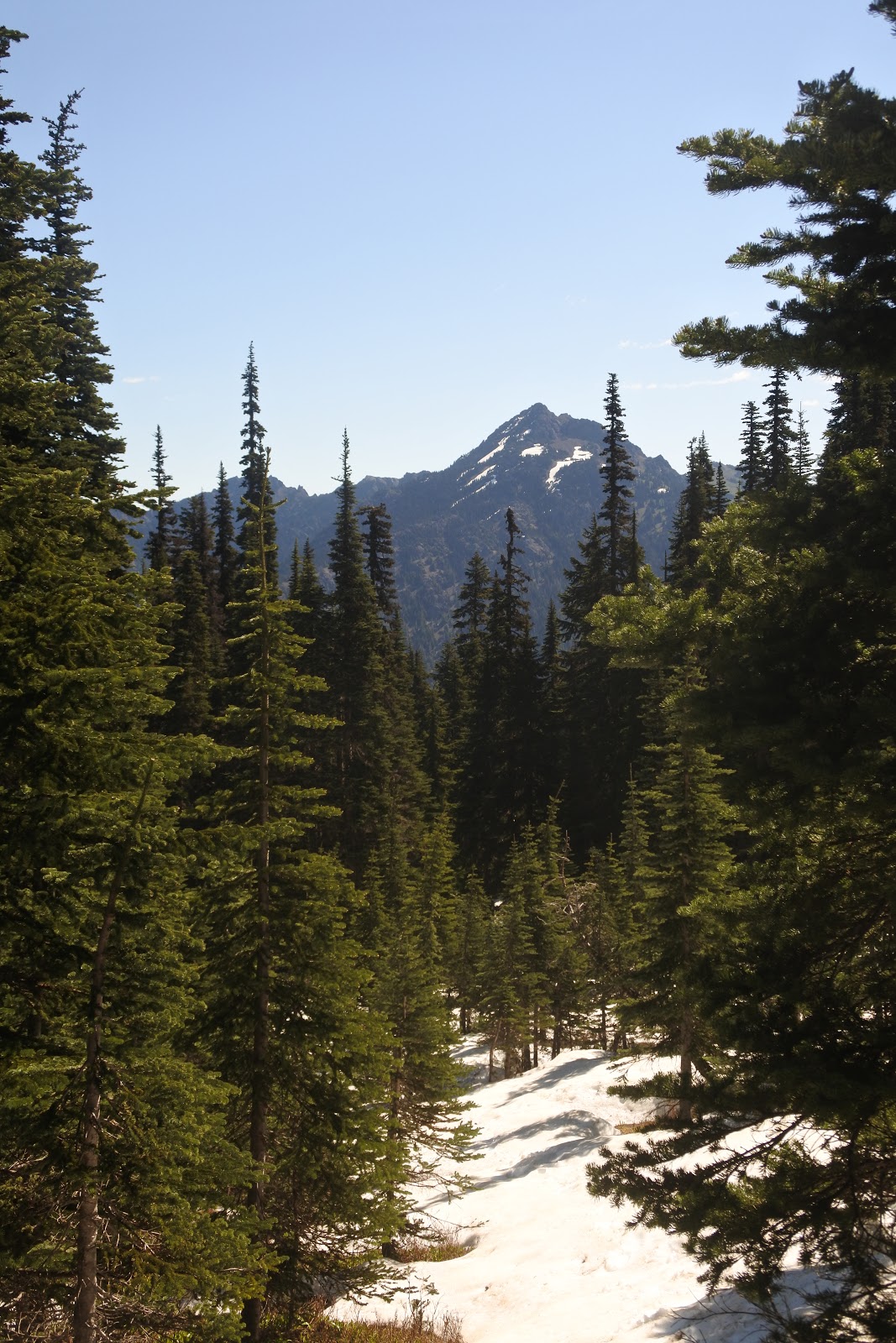
View of Mount Angeles, biking back from the Elwha River

Sunday — The run
I went through the bleary motions of the early morning: oatmeal, last minute fussing with my backpack, the hydration bladder.
I walked out and shut the door — knowing I wouldn’t open it again until many hours and miles had passed me. Everything was in place. Time to roll.
I shuffled through the gray neighborhoods with still-stiff muscles. The bright light of sunrise had already torched the white summits of Klahhane Ridge at 5:30 a.m. A muscle car growled from door to door as the paper boy flopped the news onto slumbering doorsteps.
I had slept in a bit, and was about an hour behind my planned start time. I imagined that I still had plenty of time to make the 40-some-mile journey, but still worried about unknowns like staying on the trail up on high where there were likely to be a number of fallen trees along with snow drifts. What would the river be like when I got there? Would I have the energy to run whitewater after running up and over a mountain? 
There were so many questions, but I forced my brain to slow down and focus on the present. I had just turned back onto the Sasquatch Trail, and it would suck to turn my ankle when the run had just begun.
The sun’s illumination filtered moody orange through the top branches of the spruce and cedar. I grabbed the nylon strap on the trip log and swung my body over the gully that had almost eaten me the other day.
Horses in their pastures along Black Diamond Road turned their heads as I went by.
I didn’t feel strong, but steady. I kept glancing up to my watch, setting and revising expectations of where I should be and when. I knew that each time I dawdled or slowed would accumulate onto others, adding up to hours to my finish.
Even so, sloshy guts forced me to take a bathroom break near the Little River Trail. I felt my intensity start to slack as I began trail running. The Little River trail starts, wide and well-graded, but evolves into a twisting, rocky beast, with steady elevation gain.
The Little River was a welcome companion, feeding my spirits with its bubbly cascades gushing between mossy boulders down to pools of cold clear water. Behemoth Douglas firs climbed high along wet black cliffs, pressed up against the edge of the trail. Filtered sunlight seeped through the Lothlorien canopy to glint on the big-leafed maples and stalks of devils club. 
I got a little shot of adrenaline each time the trail cut the river. The bridges were made from fallen trees with railings added on and the top sides planed down into flat walking surfaces.

The Little River


Eventually, that river water would find its way down to the Elwha, and hours later I would get to paddle over it. 
The trail veered off from the river to began a series of switchbacks, putting the elevation on. Forty minutes later, it flattened out and I was looking at a bog land covered in devils club and stinging nettle, wondering where the hell the trail went.
I wandered for a while, scraping with the thorns and stings until I finally re-found the trace. The trail had narrowed now and there were several fallen trees to scramble over and around. I hit my first patch of snow about thirty minutes above the bog. The snow began to coalesce around the trail as I continued upward. A couple times I put my foot through in places where melt had hollowed  it out. More than once, I lost sight of where I was supposed to go and wandered here and there until I found found the trail again.
I was now a couple hours behind schedule, but still in the green zone as far as where I felt I could be. When I finally lost all trace of the trail in the snow, I was still a hundred feet or so below ridge line.
It was easier to forget it and go strait up.
I topped out to a spectacular southern view of the Olympic Mountains lined up along the Elwha Valley, sharp white peaks and glaciers above the deep green and gentle lowlands. My heart surged with the pure rightness of it all. How was it that I equivocated or ever doubted that this was what life required?

The south-facing side of the ridge had was far less snow. The environment was a combination of scrub trees and alpine meadow — which was lately coming into spectacular bloom with purple lupin and harebell flower.
 I wish I could say that Hurricane Hill was some remote and seldom-seen promontory  tucked into an obscure corner of creation. It is, in fact, one of the most visited attractions in Olympic National Park, a reality that may or may not be tied to the access road that you can use to drive up the first 5,000 feet of the 5,700-foot climb.
Soon, I was weaving around the phone-looking hordes (who probably assumed that I was had started from the parking lot like the rest of them.) They walked with water bottles in hand, trampled the alpine vegetation to put a better image of tame deer on their screens.
Despite all the company, I was no less moved by the view from the top. Distant Mount Baker glinted in the distance. I could see over the south corner of Vancouver Island and mentally retrace the kayak trip that I had taken there a few weeks before. 
Port Angeles Harbor, over a mile below, looked small and distant, but that was where I would be paddling. Eventually.

I ran back down the way I came, then turned onto the west section of the trail, which goes down to the Elwha River. This was the only part of the trip I hadn’t travelled before.
Mount Angeles, as seen from near the
top of the Little River Trail
Two middle-age woman were walking up the path from the other direction. 
“You can’t go this way,” one of them told me.
“Why, what’s going on?” I asked.
“There’s snow on the trail,” she said.


Indeed, there was snow on the trail. That was the fun part. I let myself pick up speed and slide downhill on my running shoes, leaving long skid tracks behind me. I admit that if I had brought skis on this doorstep adventure, it would have really been the trifecta. Lacking those, shoe sliding would have to do.
I took lunch in the high meadow, cutting up avocado onto tortilla bread. There were flowers all around and views south to glaciated Mount Olympus and remote valleys. It was so beautiful that I started laughing. 
A half-mile away, the hordes were marching from the parking lot to the top of the hill. If it was the snow that scared them away from this peaceful place, let there be snow, I thought.
The trail continued down through meadow switchbacks. The route was so seldom travelled, I had to stop once or twice to re-find the tread in the grass. I noted the many, many strawberry plants on the path, not yet in bloom but sure to yield sweet fruit in the sunny exposure. 
The Elwha River rushed far below. I traced the cut of blue water through the empty reservoir behind the former Glines Canyon Dam, saw where Boulder Creek came down from the hot springs that I had visited back in April.
It had been a while since I’d run down a mountain and my legs felt it. I would have to lose a mile of elevation to reach the river at 300 feet above sea level. It was exhilarating all the same, being able to dance with the landscape in that zone where nothing mattered except staying on my feet
I crossed a cascade and drank the fresh mountain water with a LifeStraw my mom had sent me for my birthday. The device looks like an oversized vape-pen and made me feel as though I were toking up from the mountain itself. Healthy alternatives, kids!
After a couple more quad-pounding miles, I finally popped out on Whiskey Bend Road, then jogged a short ways onto the Olympic Hot Springs Road. It was around 2 p.m.. A trail detour took me past the river washout. Before I got back on the road, I spied a patch of baby blue above the riverbank on the other side. That was my kayak.

Alpine flowers

On The River
Despite the poor job I had done of hiding everything, I found all my gear present and accounted for inside the kayak. I dragged everything over to the launch spot I’d picked out the day before.
Now, it was time for the boring part of changing all my gear around as I transitioned from mountain runner into river paddler. I worked beneath a broiling sun, putting things in dry bags and using carabiners to hold gear in place behind my seat. It didn’t just need to be waterproof, it needed to be flip proof, and not entangle me if I needed to get out of the boat fast.
The gear left no room for flotation bags. If I flipped, the boat was going to get very full. I belatedly realized that I had left my helmet behind. There was another reason to be careful.
I was finalizing preparations when nature called again, forcing me to climb up through a steep, brushy hillside so I wouldn’t be right next to the river.
I stumbled back to the boat and put my drysuit on. In the hot weather, I was steaming myself in no time. Yet I soon cooled by wading out into the eddy and crouching down in the icy water. I took a hit of river through my straw and rejuvenated myself. It had been almost an hour since I’d gotten here, but was ready now.

Well, probably ready.
A set of Class II+ rapids with large standing waves waited just downstream of my put-in with dangerous branches waiting on river right. This was the first time I had done any proper river kayaking in a year. Time to knock the rust off. 
I swung out of the eddy and the current whirled me around. I dodged the branches by paddling over a cobble bar, then I hit another wave train, gouts of water crashing onto my chest, into my face.
I spun into another eddy, heart pounding, involuntarily grinning and laughing. Man. I had forgotten how much fun you can have on a river.
The Elwha was a meltwater stampede, charging full power out of the mountains. It ran reckless, crashing into the sides, thrashing out new channels where roads got wiped out sometimes.
In the next 10 miles, I would drop 300 feet to the sea through a series of rapids. Fortunately, there weren’t so many dangerous hydraulics or keeper waves, that would flip a kayak — at least if you didn’t count That Dam Rapid which I planned to portage. 
I also kept my eye out for wood jutting out to grab a kayaker. It’s always a concern paddling on the Olympic Peninsula.
I surged down past the park entrance where people cheered me on from the river’s edge. From there, it was a series of fun twists and turns down to Highway 101. I paddled carefully beneath the bridge, mindful of wood hung up around the supports.
Beyond this place, the river enters the former Lake Aldwell upstream of the recently demolished Lower Elwha Dam. Stumps the size of tiny houses flanked the gravel river banks. They were the remnants of the ancient forest that lumberjacks had cleared before the land was flooded. Notches cut into stumps’ sides showed where they had made footholds to stand and cut at the narrower part of the trunk above. Those stumps had sat underwater for a century.
Now I saw bright green shoots (alder, or maybe black cottonwood) growing out of the old wood to regrow the forest and make shade for the returning salmon.


Paddling the river, down past the 112 bridge and the hatchery rapids


A couple miles later, the river narrowed into a deep canyon, picked up speed. There were sections where I suspected that the soft rock had been undercut. The current moved straight into a wall, but no water splashed up and I saw no other sign of resistance. It was running right through. These were the places you needed to try like hell to avoid.
My heart started pounding when I heard the roar of a rapid from the river up ahead. 
The name That Dam Rapid is cute, but my memories of it are not.
Two years ago, stupid and overconfident, I decided to try and run that rapid — a decision that led to me being flipped over and pushed underwater, only to resurface through a series of terrifying drops, narrowly avoiding getting hung up on an outstretched log waiting at the bottom. The rapid, at the former dam site, reportedly still harbors dangerous metal debris that could snag a swimmer like a fish on a hook. I had escaped that outcome last time, but I wasn’t eager to tempt fate again.
The portage took me over an uphill grunt over loose rock, followed by a downhill slide over the same. I ended up sliding my boat down with the help of a rope to avoid toppling over and breaking myself (It would have been ironic to have hurt myself going the “safe” way.)
The river continued swift through a dark canyon, with the Highway 112 bridge far above. Not far beyond this, the river compressed for the rapids at the salmon hatchery. The boat bucked over a sharp series of standing waves. I saw a couple people who were tubing on the easier waves downstream, said hello.
The river was starting to mellow as it neared the Strait and the land became graded more gently. I took a side channel for the hell of it, and ended up having to get out of my boat to carry it over logs.
A bald eagle rested in the tree overhead. On the next bend in the current, three merganser ducks with feathered mohawks swam with the current and took off at my approach.
Suddenly, a brown bolt flung down from above — the bald eagle with talons outstretched made a dive and missed — barely — one of the ducks, which flapped away. The bigger bird flapped over to the next tree and settled back into its roost, unperturbed
Tall bluffs of cobble and clay lay in front of me, indicating the sea was near.
Now, I could see the mountains of Vancouver Island in front of me, hear the shush of surf pounding onto sand. I adjusted my posture in the seat, preparing for combat. The place where the current meets the oncoming sea is often fun, often tricky.
I paddled through fast and shallow water as the first waves pushed up the current to meet my bow.

Portaging over a fallen cottonwood

The Strait and Port Angeles
Waves were curling, breaking off the nearby sandbar. Acres of fresh blue water pushed their way out into the salt. You could see a clean break where the brighter, glacial colored river water met the darker, brooding water of the Strait. The region was troubled by swirls and popping little waves.
Two black eyes emerged from the water as a harbor seal came up to take a look at me.
The waves coming in weren’t particularly big, so I decided to look for trouble and point right for the agitated water. I got in a few exhilarating rides, surfing waves up the river current, leaning in as the water broke over my head. 
“Whoooo!”
I wanted to surf there for a longer time, but it was hard to stay in place without the river and the tide pushing me out of the fun zone. Fine, I needed to go east anyway.
The Elwha River silt creates an enormous bulge in the shoreline known as Angeles Point. The point creates an extremely long break which had been a favorite of surfers for years, though shoreline access from the reservation there is off limits now. I am always wary of the spot because the break comes on quickly and drops so fast it can throw you on dry beach before the water gets there.
I made the mistake of fooling with my camera for a minute, then noticed a near-vertical wall of water rising up over my head. I feebly sank my paddle in and tried leaning left, but it was breaking too fast and it rolled me over. I rag-dolled in the foaming water until I hit the beach, pushed myself off the sand and righted myself. There was barely time to breath before the next wave came crashing in. The broken water freight-trained into my chest, almost sending me backwards with it. I had to fight three more breakers until I got past.
I was quite pleased to see my camera and my glasses were still with me, but my hat…Dammit, where was my hat?  
I caught one glimpse of it in the break-zone before another wave crashed over it and that was it. I paddled up and down the beach, and there was no sight.
I felt bad because it was a new hat that I liked, and also for contributing to the plastic pollution in the sea. All I can say is I hope someone finds it out there and wears it, and that it doesn’t end up in the guts of a whale.
I took a break on a beach to make a Father’s Day call to the east coast as the sun got lower in the sky. I explained that I was still out on my journey, but I was getting close to home and things were looking good.
The sun laid a golden path over the Strait as it lowered over Vancouver Island.
I cruised for another three miles across open water with waves and tide pushing my little boat east to Ediz Hook, which I would portage to the harbor in order to save a couple miles. The waves were breaking here too, which made it tricky to time a landing, but I managed to hop out and get the boat pulled up the riprap. It was way easier than it had been taking a sea kayak over those boulders last year.
The harbor was easier paddling, protected from the ocean swells from Ediz Hook. I heard a sea lion barking from a log raft. The last light on the mountains above dimmed, then flickered out. I paddled under the city dock at around 9 p.m. and landed my boat on Hollywood Beach. 
Not done yet.
I propped the boat up on a seawall, and lifted it up on my shoulder straps.
No way to avoid attention now. I passed people eating their dinner on outside patios, enviously eyeing the cold beers on the table. I waited for someone to ask me what the hell I thought I was doing walking through town with a kayak on my back.
“Whoa man, that’s awesome!”
“That’s how you do it.”
I stepped a little prouder. I was really pulling this thing off. The chill I felt during my last mile of paddling left me as I climbed the steps to the top of the bluff above downtown. I felt the shoulder straps cutting off blood to my hands. They were both going asleep. I didn’t want to take the kayak off though, so I counted the streets: 5th street, 8th, 14th. Finally, at Lauridsen Boulevard, I threw the burden down so I could drag it along the grass by the new supermarket. Half a mile to go now. 
I lifted the thing back up to make the final push up the hill. I walked into the yard as the courthouse chimed 10 p.m. 
There was the doorstep, axis of my life. Grateful, I threw my burden down a final time that day and set it by the fence. The sky was dark magenta over the waters of the Strait. The mountains above were dark with cold blue snow. I walked inside and went to my room. Now that it was complete, I had bought myself a small respite from the unending restlessness. It was another box I could check off the long list of Olympic Peninsula adventures. Tomorrow morning, I’d start the great clean up.

Struggle never ends.


Wednesday, June 20, 2018

Lone Wolf Island: Part III


Rhododendron blossoms float above eelgrass in Victoria Harbor near Esquimalt
My last day paddling in British Columbia took me through some of the trickiest paddling conditions of all, right through the harbor entrance. Once inside the harbor, however, the paddling became a whimsical garden journey beneath blooming rhododendrons and past rustic wooden boats. It felt like I was in a Monet painting. If only there were a good place to get a cold beer dockside…

A bald eagle landed right next to my kayak as I ate my breakfast on the rocks up shore.
The tide was coming in on Discovery Island. The water inched up along the clumps of bladderwrack. Tide pools warmed to soupy temperatures beneath the overbearing sun. The pines jostled each other as the wind picked up and whitecaps were already marching down the strait. The wolf was somewhere around, I’m sure, but he would remain a mystery to me. It was all the more reason to visit once again.
My journey back to Port Angeles would have me retrace my paddle strokes back to Victoria, across the tidal rips in the Chain Islands and against the wind and the flood tide. Before I got back on the ferry, I wanted to to explore the upper reaches of Victoria Harbor, which extended about six miles north above the entrance. I was already excited about the long day that I had put in the day before, and wanted a pleasant victory lap.
As it happened, the elements wouldn’t let me lapse into self-satisfied congratulation so easily. The wind came roaring and relentless across the Chain Islands, slowing my progress to a crawl. Once I reached the Vancouver Island mainland, I had to add extra distance to my journey in order to duck in and out of bays where the wind wasn’t so strong. The tidal current was almost as relentless. Once I got to Trial Island, I was basically paddling up a river. I deliberately paddled through thick clumps of kelp in order to avoid the relentless water. The kelp eventually thinned out and then it was just me against the tide. At this point, I was thrashing at the water to keep any momentum going and to prevent the boat from spinning. Still, I could hardly mark any progress against markers on shore.
The current relented a bit once I got past Trial Island, but the wind did its best to pick up the slack. White caps came on short, fast and angry against my boat. The shoreline flattened out and there were fewer points to hide behind. At this point, my bladder was getting strained, but I was unwilling to lose time to a shore landing. There were plenty of people on the beaches anyway. 
I decided to use some exposed rocks as wave cover, and throw feather boa kelp over my deck to anchor the boat. It worked well enough to get to half empty, but then a larger set came in and almost dumped me in.
The biggest challenge was getting through the harbor entrance. The breakwater was beautifully decorated with native art. The hard concrete also created a flat surface for the waves to bounce right off of, creating sharp, unpredictable intersections with the original wave set. Usually, I wouldn’t paddle right next to the wall under such circumstances, but the steady boat traffic to my outside pinned me there like a rush hour pedestrian pressed beside a guardrail.
The wakes added another element to the chaos. I paddled headlong against tide and wind, as waves buffeted my boat from all sides. Up and down I went on the bronco ride. Gallons of water slopped over my deck. There was a small group of people watching from the breakwater. I felt proud that I was keeping cool, doing the minute corrective strokes here and there to get through it upright.
As I rounded the corner, I immediately started surfing waves into the harbor. The flood tide was with me now, and I moved at high speed. No cruise ships were parked in the docks yet, but I was anxious to get past their loading zones sooner rather than later.
I saw a twee little water taxi turning around in the center of the channel — as it took a massive wave broadside, jolting the boat and knocking it into a whole different angle. Watch out little dog! You just wandered into a rough part of town.
Further up the harbor, the big waves from the Strait abated, though the big winds still stirred up dark cat’s paws on the water.

Feather boa kelp on deck

I paddled past the ferry terminal going north beneath a drawbridge. I had to stop here as two high-masted sailing ships gurgled out under motor. 
The harbor noise included the clatter of a backhoe mounted jackhammer, busy smashing the old drawbridge to bits. There was a curious barge mounted up with hundreds of vehicles, all smashed up into a single rectangular box.
Yet the industrial milieu fell away as I continued up the harbor. A long pedestrian bridge facilitated a unceasing stream of bikes and walkers. Lush madrona trees overhung the waters.
There were several boats anchored in the harbor that looked like they had gone a long time without fresh paint scabbed over with seaweed and barnacles. It dawned on me that people lived there. These were the more affordable alternative to the tony houseboats that I had visited on my first day in the harbor. A couple of the boats had tarps set up over them for additional shelter. One may have had a chicken coop. It’s be interesting to learn about the folks who live in the middle of this incredibly expensive town in a free and floating community. I made a mental note that if I practice sleeping inside my kayak, that this could be the ultimate cheap lodging in Victoria.
Victoria gave way to its suburb Esquimalt, where beautiful rhododendron trees bloomed along the water. Petals dropped upon the surface created mesmerizing interplay between the worlds on, above and below the surface. M.C. Escher would have been proud. 
I floated among the color unhurried, letting the tide carry me deeper into the harbor. The current picked up in the narrow gorge around Tillicum, to the point that I could see swirls and eddies as I shot beneath a bridge.
Right before the north end of the harbor, the sand became to shallow to paddle through. I began paddling against the tide once more, though now I had the wind at my back at times. 
The water was greenish, bath temperature. The sight of people wading, an elderly woman in a sunhat practicing the breast stroke, made me feel foolish to be in a drysuit meant for cold water paddling. I was roasting beneath the sun. Being lazy however, I decided it would be easier not to have to pack the suit away inside my kayak, or to manage the extra weight when it was time to lug the boat onboard the ferry.
The tidal opposition became the strongest when I reentered the gorge, The narrows at the bridge there were so extreme that I literally needed to paddle uphill in order to get into the higher water backed up behind it. This I accomplished by paddling as fast as I could on the other side of the eddy line, and swerving into the current at the last minute to break its strength. Even then, I barely made it past the bridge without going backwards.

Smashed up cars onboard a barge

For the past 24 hours I had fantasized about having a beer at a local kayak business, which also ran a dockside pub. Alas, by the time I paddled back to this place, it was already getting close to the time that I wanted to be onboard the ferry. I knew I could probably drink it in time. but I also knew that to truly enjoy it, I wouldn’t want to feel rushed. 
I later calculated that I’d managed to knock out 23 miles of paddling all together. Even on the easy day that I’d planned, I hadn’t relaxed exactly.
With no handy public dock near the ferry, I ended up revisiting the same footbridge where I’d taken my boat out of the water the year before. This time I managed it much more smoothly, taking most of the weight out of the kayak and into a backpack/drybag. 
“You know you can get wheels for your boat,” someone told me.
Customs and the ferry ride were both uneventful, though I ended up striking up conversation with a couple riding motorcycles across country from New Mexico. They were kind enough to watch my gear when we got back to Port Angeles so I could pick it up with my car.

I drove the two miles up to my apartment, began the tasks of unloading gear to be washed with more zeal than I typically have after these long trips. Before I went to bed, I ran around the block. This  doesn’t really make sense if I were dead tired, except, I knew that I wasn’t dead tired. I had more in me. The next time I went paddling, I would prove it.


Bridge inside The Gorge


Wednesday, June 13, 2018

Lone Wolf Island: Part II

Mount Baker and kayak on the north end of Sidney Island, the
turnaround point for my adventure

My adventure kayaking around southeastern Vancouver Island continues. 
On Day One, I paddled out of Victoria, the British Columbia capital, to isolated Discovery Island where I made camp. There was no sign of the famous wolf that makes its home there, but I did get to share the campfire with Sandy, a fellow kayaker who lived in Victoria. Waking up the next morning, I got to decide what I wanted to do: spend a chill day poking around nearby islands, or go for a long voyage north, fighting the elements in the open water in order to put down my longest single day of kayak mileage thus far.
Guess which choice I made.

Life would have been easier for me if I’d woken up and the sky was dumping buckets of rain or if a hellacious gale was ripping across the water.
I probably would have anticipated the misery of going for a long trip and opted for a short day’s paddle around the Discovery Island archipelago. Unfortunately, I crawled out from my tarp shelter to see soft, inviting orange light climbing down the slopes of the Olympic Mountains in the south. The Strait was wind ruffled, but not churning; the sky was baby blue. 
What a shame it would be, I thought, not to capitalize on these fair conditions. I would grow restless dawdling among these small islands, knowing that a greater adventure lay to the north of me.
That adventure was the Gulf Islands, some 15 miles to the north. There would be some long crossings, tide rips and strong winds to deal with. There was also the fact that the coastline looked boring and developed that way, so I wouldn’t have the same element of inspiration that I would have in a truly wild place.
My Canadian friend Sandy, had woken up at about the same time as me. We said hello and then largely kept to our separate camps as we tended to our individual tasks of organizing gear and packing boats. A westerly wind began to build as the sun got higher in the sky.
We ate breakfast together in the shelter of a stony ledge.
Sandy was going back to Oak Bay (an eastern suburb of Victoria) that day,  while I was to spend one more night on Discovery Island. My tarp would stay up as a welcome place of rest once I returned that evening.
Since Sandy had some extra water, he let me top off some of my rations. I even went as far as taking some of his cooler ice that he was going to throw out and packing it into my hydration bladders.
Since we both seemed to be taking about the same time to leave, we ended up starting our trips together, paddling around the east side of Discovery Island.
Along the way, we both had fun shooting “field goals” between shallow rocks and the cliffs. Wildlife was everywhere.
“Check out that a seal at three o’clock.”
“Bald eagle at 11.”
“The crows don’t seem to be happy about him being there.”
“Seals on the rock at nine o’clock.”

Seals on the rocks in the Chatham Islands 
The quiet, and the absence of other humans, made it was all the more incongruous to round the north side of Discovery Island and see a skyscraper shimmering in Victoria.
Rivers of sea water moved with the tides between the islands, setting the brown fronds of bull kelp aflutter.We moved through the eddies and the riffles north until we came to the last island in the chain.
That was Strongtide Island, Sandy told me.
“I bet it’s called that for a reason,” I said.
The reason was Baynes Channel, Sandy explained.  
Baynes was about a mile of open water before Ten Mile Point on Vancouver Island. The Batman villain-sounding stretch was notoriously treacherous when the tides were running.
We were lucky enough to be making the crossing close to slack however, which meant that the water was limited to some riffles and boils on the surface — no standing waves or whitewater. Still, this point was a something of a rubicon to cross. The fact was that now, I would want to come back here in either six hours or 12 hours. Any sooner or later, I would end up crossing the passage during a strong flood tide or ebb. 
The channel would stay on my mind throughout the long day of paddling ahead of me, as the hours added up on my watch and my body tired.
 “I wonder what Baynes will be doing when I get back.”

Once we got to the other side, Sandy pulled his boat on a beach to call his wife to pick him up. She’d meet him down the island.
I was sorry to say goodbye and lose the company. It was going to be a long, long paddle if I was going to reach the Gulf Islands, and I was as much worried about boredom as I was worried about the physical challenge.
Sandy had pointed out the tall line of sand cliffs that marked James Island, one of the southern outposts of the archipelago. It looked as far as hell. The fastest way to get there was to go way offshore where there would be none of the entertaining foreground scenery that came with paddling around Discovery. I wouldn’t be looking at seals on rocks or perched eagles. It would just be paddle, paddle, paddle.

The bluffs at the south end of James Island
One nice thing: I had both wind and tide at my back.
As I paddled further north, the westerly wind coming out of the Strait of Juan de Fuca swung around Vancouver Island and became a southerly. Eighteen-inch waves gave me helpful nudges, allowing me to surf occasionally. 
I took a snack break inside me boat, letting the elements push me along as I relaxed.
To keep my mind busy, I would compare distant mountains to closer mountains. The great white flanks of Baker loomed over San Juan island to the east. I marched it north with me, taking bets with myself on how long it would take for me to get the volcano to line up with a radio tower on shore. 
A few miles later, I could see the Olympic Mountains looming over the Vancouver Island foothills. How long would it take before they would appear taller than the smaller, closer mountains.
I ended up in a race with a large sailing yacht that was coming up from behind me. It had a deep purple sail adorned with the eyes of a femme fatale. 
Because traveling directly downwind is actually slow going for sailboats it took a couple miles before the pair of eyes overtook me. I thought about cutting right behind it so I could draft in the wake, but it was going too far to the west now, heading for Sidney. 
I could see planes taking off and landing from the Sidney Airport far ahead of me. If I made it that far, I would cross my paddling route from the year before. 
I made it to James Island around noon.
Yellow scotch broom flowers blossomed out of the sandy bluffs overhead. 
OK, I thought, I have officially reached the Gulf Islands. It might be a good time to turn it around now.
Instead, I ended up paddling five more miles between James Island and Sidney Island. A long sand spit came out of the north side of Sidney Island. I knew that beach, because I’d been there last year. I pulled my boat up to eat lunch. 
The view included five separate mountain ranges. I had finally gotten far enough north to see the Vancouver Island Range. The six-thousand-foot peaks had plenty of snow on them. To the north, I could see the Canadian Coast Range, some distant 8,000-footers like Mount Tantalus near Whistler. The view of the Cascades included 10,000 foot Mount Baker. It may be a stretch to call these mountains, but there is a 2,000-foot peak on the San Juan islands, so I will include them in my roster. Finally, there were the dear old Olympic Mountains to the south. They were far enough away that I could see the whole range, east to west. It was a reminder that I needed to get back eventually. 
The wind was going hard, so I found a sheltered spot to eat. I wolfed down sandwiches and granola to supply the energy that I was going to need very soon. 
On the one hand, I was elated to have reached the same point that I had paddled last year, this meant that I had an unbroken line of paddling experience from Port Angeles to the middle of the Gulf Islands. On the other hand, I knew that I was going to be fighting wind all the way back to Discovery Island. I would end up adding extra distance cutting into bays for shelter. I was at the halfway point of my journey, but I was nowhere near halfway done. Also, I still had to cross Baynes when it was all done.
It was 2 pm. I needed to get to Baynes somewhere around 7 or 8 pm to have the best chance of getting across safely.
That seemed like a lot of time until the headwind slapped into me. Dammit. I felt like I was barely moving at all.
It took almost two hours to get back to the top of James Island, the place where I thought I would turn around originally.
I stuck close to shore, but their were barely any places where any points stuck out far enough for me to get a break.
At one point, I just ended up hopping out of the kayak and towing it along the beach for a ways. This worked, OK for a while, but once the shoreline started getting rocky, I started tripping in the water. The waves made the water murky so I couldn’t see what the hell was going on beneath the surface. It was 5pm now and I had made it maybe halfway back.
When I got back into the clear, I saw the fronds of bull kelp were waving to the south. That was good, because I knew the current was with me now, yet it hardly mattered against the headwind.
“Wind trumps tide,” I muttered. It’s an expression my dad likes to use, and it’s true. 
The wind finally began to shift as I continued going south. It began to turn back into a westerly wind, meaning it was coming more from the side.
While this made for faster paddling, it also made for an unnerving crossing with the waves pushing me away from shore. I knew that if I flipped my boat would end up going east for about 10 miles before I ended up on San Juan Island in the U.S.
The light was getting lower over the mountains now. My watch beeped 7 pm. I needed to get to Baynes soon or it was going to be a shit show getting across. Would I try crossing if it was dark out, or would I just bivuac in the suburbs somewhere?
It was especially concerning that I couldn’t even see the islands yet. I rounded another point expecting them to pop into view, yet I just saw another point to go around.
I paddled fast. The wind was no longer fighting me.
Suddenly, I realized that I was seeing the islands. In the low light, I didn’t realize that the point I was looking at in front of me, was actually Strongtide Island — separate from Vancouver Island. Relief swept over me. I was much closer than I thought.
Baynes was moving by the time that I got there, but I was still close to the slack. 
I steered around passages with larger wave trains. Finally, though, there was no avoiding it and I just dug in. I’ve got this. I thought. I’ve paddled through way harder stuff.
I reached the edge of Strongtide Island and turned around to look back at it all.
The reflection of the setting sun cast all kinds of weird light over the boils. The waves were torched with sunlight; they marched like ocean acolytes along the path of the rip.
The sun was down by the time I got back into camp. Cold hit me immediately and hard. I clenched my jaw as I struggled out of my drysuit, shivering violently and cursing. Pre-hypothermia stuff. It is amazing how quickly it can come on when you are tired and you stop moving.
I peeled out of the wet stuff, piled on the dry. By the time I had a fire and hot soup, I was coming back around.
I didn’t know it yet, but I had paddled 40-miles that day. It is, so far, the furthest I’ve paddled in one day. What I knew was that I was pooped, but my muscles had basically held up. I felt proud of putting in a full day and for connecting the Gulf Islands to my web of adventures out of Port Angeles. I hadn’t blistered or injured anything.

This was good news because I had one more day of paddling ahead of me in order to get back to Victoria and home.

Some of the weird water near Baynes Channel

Klahhane Ridge in the Olympics as seen from the water off Discovery Island

Friday, June 8, 2018

Lone Wolf Island: Part I

I spent three days and 79 miles of kayaking out of Victoria, British Columbia, including two nights on Discovery Island, home to a solitary wolf. On Day One of the Adventure I make it through customs and ninja launch my kayak in Victoria, then paddle through chop water and tide rips to get to camp for some exploring around the island archipelago. Total Mileage: 17 miles of kayaking.

I’m not sure if the customs guy liked me very much. 
That whole “I am pissed that you are here, and you are wasting our time,” shtick must come standard in the training.
In fairness, though, I was taking up some time and resources at this port of entry. I had already cut to the front of the line of arrivals, while one of his fellow agents carried the back half of my kayak.
“You know you can get wheels for these,” he told me.
“Yeah, I’m going to look into it.” I said. It was probably the third time someone made this suggestion this morning.
I was the only passenger to carry a kayak on board the ferry from Port Angeles to Victoria, Canada — an extra $6.50 fee on top of of the standard passenger fare.
The goal was to paddle east out of Victoria’s harbor out to a campsite on Discovery Island, nine miles to the east. The island had been closed to residents until only recently because of the island’s latest resident: a solitary coastal wolf, which had somehow crossed through the Victoria suburbs and swum through some nasty currents to end up on Discovery Island alone. The wolf was still there, but the camping ban on the island had lifted recently and I’d decided to spend Memorial Day weekend out there for some lone wolf time.

Before I got to all that lovely paddling and full-moon howling, however, I needed to get my boat to water.
I almost slammed the door-jam with the paddles jutting out of my pack walking into the customs building. I went through the door with a halting squat-shuffle, that didn’t look at all suspicious or draw attention.
My fears of getting turned back, or shipped off to an interrogation room turned out to be unfounded, however.
No one checked to make sure that the hatches weren’t stuffed with weed or severed rhino horns. I couldn’t blame them if they weren’t in the mood to sink their limited staff resources into going through my dry soup mix and fleece clothing. I was out on the street in minutes.
Vendors and tourists mingled on the concrete walk above the harbor. There was no more help carrying the kayak now. It sure was heavy with all the gear. I just needed some water underneath me, and everything could float. Unfortunately, there was also an-eight foot seawall and a chain fence separating me from that bliss. The docks were all marked private. Well…at least there were no signs saying anything against going over the chain and launching off the sea wall.
Fifteen minutes out of customs and it was possible I was already a criminal.

Going over the sea wall with my kayak

It was shallow water below the seawall so I wasn’t brave enough to just shove the boat. I used a couple ropes to lower it down, and got help from a Seattle couple. 
With the boat halfway down toward the water, I heard a pshhht sound inside my cockpit. What the hell?
I saw that the beer that I’d stashed there (I was going to bribe someone into helping me carry my boat) had popped a hole for some reason. Timing!
I could have shotgunned my beer right there in the shadow of the British Columbia parliament. Yet I didn’t want to add to the trouble I was making with my sketchy kayak launch, and opted to pour the beer into a plastic jug.
I lowered the boat the rest of the way, then climbed down the ladder and put myself on board.
I paddled off, into the harbor, (or should I say harbour, now that I was in Canada?) The spelling was one of many ways that the city was twee and Britished out. Charming little yellow water taxis with checkered stripes ferried passengers around the harbor under electric motors. Above it all, the buildings broadcast a complicated Victorian (what else) architecture with all the fussy peaks and balustrades.  Sea planes rumbled over to the west side of the harbor, gained speed and ascended into the blue, cloud-streaked skies.
I drank beer out of the jug than got out of the boat to use a water fountain to fill up my stores for the rest of the trip.
Back on the water, I came upon an elegant wood schooner with high masts and green trim: Blarney Pilgrim. A man I took to be the captain was standing topsides.
“You wouldn’t happen to be from Ireland,” I asked.
“No, the ship’s named after an Irish reel.”
I told him I played mandolin and would have to look that one up, and he invited me to come to the local jam that he played in.
Perhaps I will make it out one of these days.
One of my favorite Victoria Harbour attractions are the house boats. They are grouped together in a colorful neighborhood moored off a series of peers. As a kayaker, I got to voyeur my way around, paddling beneath window frames, while the tourists were confined to the boards.
I was enjoying paddling the harbor so much that I didn’t want to leave. And look, here was a for sale sign. I just needed some money and some citizenship and I’d be good to go.

The twee Victorian sights began to industrialize as I paddled away from the city center toward the open water.
Here, diesel pilot boats waited to help guide the big ships into the harbor. One of these big ships was roped up in a berth near the harbor mouth. Celebrity X Cruises, it read on the side of the towering box of glass and plastic. It looked like a piece of Atlantic City that, for some awful reason, was afloat on the sea. Nothing in the design spoke to the grace of wind or water. 
Were their celebrities aboard now? If so, I was sure they were loathsome and insufferable.
Oh, Christ, there was another one of the damn boats coming into the harbor now — seven stories tall, coming in hot.
No way I was waiting for the next shiny piece of sea trash to park. I began paddling like hell to get across to the sea wall.
Sharp waves slapped across my bow. A flood tide brought checked my progress with an opposing current. The water turned to washing machine chop as waves from the strait bounced off the seawall, crisscrossing each other. 
Finally, I got out of the path of the oncoming ship, but the waves were goofier than ever. 
I stayed within a paddle length of the wall, staying in the wildest water, but where I would be least likely to be surprised by a speedboat cutting the corner. A couple spectators watched me from above.
“Now comes the fun part,” I called to them.
As I prepared to round the corner I braced my knees hard up into the cockpit so that I could react to big slammer waves that were waiting for me there,
Suddenly, I heard the roar of an outboard going full throttle.
“Oh shit.”

THUD —- THUD —- THUD — THUD —- THUD —- THUD

The oncoming boat slammed off the waves.
The driver came within 20 feet, throwing foam in its wake. I concentrated on moving forward and maintaining stability. Finally, the wake hit me, a second later, I was taking rebound waves coming from the opposite direction.
Now that I was outside the harbor, the flood tide was moving in my favor, carrying me Northeast toward the vast Strait of Georgia, which lies between Vancouver Island and the North American continent.
Speaking of flooding, I needed to pee very badly. The beer had run its course. The beaches, alas, were crowded, and I felt badly about offending Victorian sensibilities with public urination. 
My best hope was to pee out from my kayak, which was going to be extra challenging in the waves. I opted to steer behind some rocks where the water was slightly calmer. I pulled the sprayskirt, tugged the relief zipper on the drysuit and aimed the stream outside the boat. The kayak lurched as the diffracted waves buffeted me from either side. This operation required me to have hands off the paddle, so the only stability was in the hips. 
I emptied about half my bladder,  and almost capsized as an extra large wave set smashed past the rocks. Half relief was better than no relief, so I would leave it there.
I paddled back into the current, and worked at catching waves to make fast time.
Up ahead of me stood Trial Island, a windblown place of grass and rock, adorned with skeletal radio towers.
 The island created a bottleneck in the current, so that the water took on a riverlike appearance. The waves compressed into something smaller, but hard. It was lean, dark, muscular water, rippling with strength. Little whirligigs whipped off of the eddy line. Circular boils blossomed out from unseen depths.
The kayak sped like a over it easily; life was good as long as I didn’t defy the forces around me. Yet, my curiosity was stoked, so I flipped the kayak around and tried paddling. Even giving 100 percent of my effort, I saw that I barely made any progress. I had to focus to keep the boat from bucking out of line. Finally, I bent to the current’s wishes and let my boat swing back downstream. As far as I knew, I was getting close to the end of flood tide when the water should have been slacking off.  In other words, this beast was not going anywhere near full strength. Trial Island indeed.

After the tide rip, I paddled another mile to a golf course, which was at the southwest corner of Vancouver Island. Here, the shoreline bent northwest toward the Strait of Georgia and Port Hardy at the top of the island, 275 miles north of there and halfway to Alaska.
I was leaving that shore to paddle two miles out through the chain islands to Discovery Island. A friend who had been out this way before, told me to watch out here, because those islands channeled strong rips between the Juan De Fuca and Georgia straits. 
I hoped that the catching the tides near slack would ease the bumpiest parts of the ride.
I poked from rock island to rock island, going between kelp stands. I accidentally surprised a large colony of seals, and watched as they heaved their speckled gray bodies to the water to much commotion and splashing.
The rips produced a couple of six inch standing waves to slap through, but it was nothing too challenging. Nonetheless, I found the currents taking me further north than I planned, so I decided to just go around the north side of Discovery through the channel below the Chatham Islands to the north.*
The water here was calm, private. The islands felt a world removed from the bustle of Victoria, marked by solemn pines and beautiful madrona trees meeting hanging out above their reflections. I spotted bald eagles up in the branches, monitoring my progress. This land all belonged to the Songhees First Nation, so there would be no landing there.
And as for the wolf? There was no sign.
When I rounded the south side of the island, I was back in the teeth of the wind. Fortunately, camp was not much further. A small sandy bay offered a protected place to land my kayak.
There was a small, windblown meadow above the beach with picnic tables and camp spots.  No one else had set up shelter, yet. And here I had been worried that I would get shut out of a site, being so close to a major city. I savored the wisdom of my taking my Memorial Day weekend in Canada, where there wouldn’t be so many crowds.
I decided to get camp set up early and do some more kayaking after. I set the tarp up and reinforced it with driftwood, set damp clothes on a sunny picnic table, weighting them down with rocks so they wouldn’t blow away.
As the clothes dried, I decided to jog the short trail nearby. The path followed the coastline to an overlook where I could look back to the USA and see the full sweep of the Olympic Mountains going east to west. Port Angeles was lost in the haze below Klahhane Ridge. Beyond, the snows of the Bailey Range shown above the distinct notch carved where the Elwha flowed out from the heart of the mountains.
Closer range, that was — yes it was! — a big ol' wolf shit! Lying right in the path!
It was a log pile with lots of hair, same as I’d seen in Minnesota. A spray of tiny asters grew around it.
I pumped my fist. It was already worth it coming out here.


Wolf sign

Another wolf sign


The wolf shit was going to be hard to top, but I decided to continue exploring. I got back to my kayak for a couple more hours paddling aimlessly through the Discovery Island, Chatham Islands archipelago. The couple of square miles held innumerable tiny islands to explore and mess around. The currents were delightfully unpredictable. I could paddle hard against the flow for five minutes only to have it reverse as I rounded a corner.  I made plenty of time to look down at starfish and up at eagles. Meanwhile, the stronger tide rips between Discovery and Vancouver Islands had picked up, and I could watch as the foam atop the churn caught the sinking sunlight.
It was whimsically pleasing to be able to poke in and out of channels and explore islands, a nice break from the aggressive point-to-point paddling that I often do around Port Angeles, where there aren’t so many islands.
I got back to the camp beach to find another kayak pulled up on the driftwood above tideline, while a man set his dinner at a picnic table.
The polite thing to do would have been to have introduced myself immediately and struck up a conversation. I was getting chilled in the steady wind though, and decided I needed to get into warm clothes before I started talking and got even colder.
Fifteen minutes later, I walked over and introduced myself.
His name was Sandy. He was a cheerful Canadian living in Victoria, who garnished his sentences with generous helpings of “Eh?” and “Dope.”
“This campsite is so dope. It doesn’t get much better than this, eh? I paddle out here all the time and there’s hardly every anyone around. People don’t know what they’re missing.”
Sandy was keen to have a fire, though the signs said this was off limits. The fact that there were cords of flammable driftwood on the beach just waiting was very tempting.
He set up a small blaze below the tideline, and I decided I wasn’t going to miss out. 
I brought my cook-pot over and we swapped stories about paddling adventure as the sun sunk below Vancouver Island.
He had a wife who was going through medical school, two kids and a third on the way. “I’m a stay at home dad.” 
“God bless, Canada.”
Life in Victoria was definitely dope. There was kayaking and biking around town and skiing in the mountains to the north. His kids were still young, but were already taking to Dad’s outdoor ways. 
In a couple weeks, however, they would all be moving three hours up the island to the smaller town of Duncan. They would be closer to the skiing here, and the cost of living would be much lower than Victoria’s. It shouldn’t have been a surprise that people of modest means were getting priced out of there — it was just like any other nice city. Tech workers and fund managers got to kick it on the houseboats,; everyone else packed their bags.

View of Olympic Mountains from Discovery Island
As I slurped down my potato/spit pea soup, Sandy showed my his Coastal Pilot book, which illustrated the network of currents between all the nearby islands and how those currents changed at different tide levels. It reminded me of the circulatory system in its complexity and interconnectedness. 
One thing the book told me, was that I could tide ride north the next morning and back south to camp by afternoon. It would be a long paddle, but I could probably even reach the Gulf Islands if I wanted to. I had explored a small part of that large chain of islands last summer, and had a great time. To get there and back, it would be at least a 30-mile commitment, however, maybe more.
 I’d figure out what I wanted to do in the morning.
Gratitude for the navigation help and the company compelled me to offer Sandy some of the apple/banana bread I’d prepared in the microwave the day before. A full moon blazed a white trail over the water. I waited for a howl to rise out of the hinterlands behind me, but there was nothing.
Legal or not, there are few pleasures like a driftwood fire. It put warmth in my bones. I felt we had a small civilization on the cobbles, complete with trade, fire, and education —  although we didn’t have a customs house, declaration forms or any celebrities to call out bingo numbers. In a few hours, the rising tide would wash right over the spot, erasing the brief history of our culture. 
I was fine with that. 
There's nothing like a driftwood fire.


*Discovery Island is named after the ship commanded by George Vancouver, the British explorer. who ventured into the Strait in the 1700s, searching for the Northwest Passage.  The Chatham Islands are named after Discovery’s companion ship, the Chatham.